ISMAP & MAGNETICS

Magnetic surveys may be undertaken by using a single magnetometer sensor, or by making gradient measurements using as many as four magnetometer sensors. Sensors may be installed on a fixed-wing airplane or helicopter.
Some of the units and structures that can cause observable magnetic responses in a sedimentary basin include:
- Pre-existing flood basalts
- Magnetic basement highs formed as a result of intrusion, erosion or structuring
- Detrital or chemically precipitated magnetic minerals in paleo-channels
- Magnetic basements flanking a sedimentary basin
- Mid-basin crustal intrusions
- Magnetic sedimentary units
- Magnetic minerals precipitated in a fault plane
- Intrasedimentary volcanics
- Oceanic crusts
- Igneous sills
- Salt diapirs
- Buried volcanic centres
- Diagenetic magnetite or pyrrhotite formed by hydrocarbon plumes
- Igneous dykes
- Detrital magnetic minerals in bar and fan systems
- Intrabasement magnetic bodies
 |
 |
|
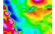
| Piper PA-31 Navajo aircraft in ISMAP configuration. | Residual magnetic field colour contour map from an ISMAP survey. |
The benefits of ISMAP are realized by the most modern instrumentation, and the state-of-the-art data acquisition and processing techniques we use, which includes 3-D drape flying, tie-line leveling, micro-leveling, equivalent source corrections where appropriate, and signal enhancement filtering. Aircraft manoeuver noise during an ISMAP survey, of necessity, is very small. Using the “Figure-of-Merit” (FOM) technique to measure manoeuver noise, all our aircraft are typically less than 1.0 nT. In addition, the use of differential GPS for navigation and positioning allows micro-magnetic anomalies to be determined to a positional accuracy of about +/- 1 meter.
ISMAP surveys are particularly useful in identifying linear or curvilinear features originating from sources within the sedimentary section. In addition, detailed comparisons of ISMAP data have been made to seismic data acquired over the same area. It can be seen that structures mapped within the sedimentary section from the magnetics can be correlated with those mapped by the seismics. It has also been found that the magnetic expression of the structure varies from basin to basin and within basins. In some cases it is consistent with juxtaposition by faulting of differently magnetized beds. In others the structure apparently corresponds to a zone where magnetic minerals have been deposited in parts of deltaic sediments; or have been uniformly destroyed or created, presumably by circulating fluids.
ISMAP surveys have demonstrated that structures can be mapped within the sediments enabling direct integration of seismic and magnetic interpretations. Without a doubt, therefore, the two techniques complement each other.
As mentioned above, an ISMAP survey generally produces magnetic signatures with an amplitude of 0.5 nT to 5 nT. Their spatial size is in the order of 50m to 100m. Therefore, it is required that the aeromagnetic information be able to resolve these anomalies to better than 0.5nT and 10m respectively. This requires the ultimate in dynamic magnetic field measurements, in navigation and positioning, and in final corrections for all the affects from diurnal variations to the “noise” created by the movement and orientation of the aircraft in the earth’s ambient magnetic field.
Unfortunately, ISMAP mapping over mature areas is difficult because of the overwhelming presence of pipelines, wells, structures, fences, towers, etc., that have small magnetic signatures of an amplitude and size of the geologic features we are trying to map. However, in frontier exploration areas where the cultural features we see in mature areas are generally absent, the ISMAP technique is ideal and highly recommended as a mapping tool.
Finally, one of the most common exploration objectives of an ISMAP Survey Program is to gain an understanding of the regional geology so that more expensive seismic surveys can be economically limited to the most prospective areas of an oil concession. The interpretation resulting from an ISMAP survey program will greatly assist in making decisions where to site such seismic surveys.
Basement Magnetic Mapping
The basement is the assemblage of rocks that underlies a sedimentary basin. If it contains numerous magnetic rock units, such as igneous intrusions or extrusives, magnetic sediments or magnetic metamorphic units, these can provide information on the morphology or the sedimentary basin and its stucture (Application of aeromagnetic surveys to sedimentary basin studies, by P.J. Gunn, 1997).
It is generally assumed that the basement beneath the sediments of interest is generally of crystalline rock. These crystalline rocks have varying amounts of magnetite, generally in greater concentrations than the overlying sediments. This high concentration of magnetite allows the mapping of the basement topography with good accuracy using the magnetic method. Also, because the basement is generally of higher density than the sediments (limestones, marble, some shales and slates, particularly dolomite are an exception) it may be successfully mapped using the airborne magnetics and gravity method (Elementary Gravity and Magnetics for Geologists and Seismologists, by L.L. Nettleton).