Navigation
McPHAR’s airborne systems are all equipped with GPS receivers for navigation and data positioning. Two different receivers are generally used; the Hemisphere Crescent R-130 and the Hemisphere R-320 real-time differential receivers.
All the GPS receivers used are interfaced to the IMPAC data acquisition, which provides navigation guidance to the flight crew by means of a Pilot’s Graphic Unit (PGU).
To obtain high resolution geophysical data, survey aircraft need to be flown at a consistent height above the ground, maintaining a consistent and safe altitude (the drape surface) on the two orthogonal survey line directions. McPHAR operates a computer-assisted system, 3DNAV, to enable our flight crews to maintain an optimal flight altitude (drape surface) during surveying while at the same time ensuring that primary and control lines intersect at the same altitude. The result is a vast improvement in the quality of the high resolution data acquired, particularly in hilly or mountainous terrain.
The Hemisphere R-320 DGPS Receiver
The Hemisphere R-320 L1/L2 DGPS receiver is provided to undertake differentially corrected GPS navigation where very high precision positioning data is required. For use with gravity sensing systems, or any application that requires post survey GPS differential corrections of the dynamic GPS data, a base station GPS receiver is also utilized.
The Hemisphere R320 incorporates internal sensors capable of receiving corrections from Space Based Augmentation Systems (SBAS), the worldwide OmniSTAR service, and DGPS beacon stations. When using any of these services, the DGPS receivers provide sub-metre accuracy at position update rates of up to twenty times per second (20 Hz). To further deliver on their promises of performance, they feature advanced COAST™ technology that enables the receiver to use old correction data for 40 minutes or longer without significant degradation of accuracy.
The R320 is built on Hemisphere GPS’ Eclipse™ platform, and boasts the latest dual-frequency patented technology. It offers 51-channel tracking with extremely quick start up and reacquisition times. The R320 utilizes RTK (Real Time Kinematic) for fast, reliable, long-range centimeter-level performance, and in addition to RTK, it tracks GPS, SBAS and L-Band (OmniSTAR® HP/XP). It also features Hemisphere GPS’ exclusive COAST™ technology.
OmniSTAR broadcasts differential corrections at L-band frequencies from geo-synchronous satellites. The OmniSTAR system achieves near worldwide coverage, extending differential capabilities to users outside free radio-beacon and SBAS coverage. The GPS antenna can receive L-band transmissions, permitting full differential GPS positioning to users anywhere in the OmniSTAR coverage area.
Features of the R320:
- Receiver Type: GNSS L1 & L2 RTK with carrier phase
- 51-channels
- 12 L1CA GPS
- 12 L1P GPS
- 12 L2P GPS
- 12 L2C GPS
- 3 SBAS or 3 additional L1CA GPS
- Feature-packed sub-20cm DGPS Positioning
- Differential options including SBAS, Autonomous, External RTCM, RTK, and optional OmniSTAR
- Exclusive e-Dif® option where other differential correction signals are not practical
- COAST™ technology maintains accurate solutions for 40 minutes or more after loss of differential signal
- Fast output rates of up to 20 times per second provide the best guidance and flow control
- Update rate: up to 20Hz position
The Differential GPS Base Station
For applications where a GPS Base Station is required to enable post-survey differential corrections to be made, a Hemisphere R-320 GPS receiver (similar to the airborne receiver described above) is utilized, complete with tripod-mounted antenna and a long antenna cable. During survey operations, the R320 uses a standard USB Flash Drive for data logging. To process the GPS data and to undertake post-mission differential GPS corrections, McPHAR uses a software program called GrafNAV.
The Hemisphere Crescent R-130 GPS Receiver
The Hemisphere Crescent R-130 is a high-accuracy GPS receiver that incorporates internal sensors capable of receiving corrections from Space Based Augmentation Systems (SBAS), the worldwide OmniSTAR service, and DGPS beacon stations. When using any of these services, the R-130 provides sub-metre accuracy at position update rates of up to twenty times per second (20 Hz). To further deliver on its promise of performance, the R-130 features advanced COAST™ technology that enables it to use old correction data for 40 minutes or longer without significant degradation of accuracy.
Space Based Augmentation Systems (SBAS) include the US FAA's Wide Area Augmentation System (WAAS), the European Commission's European GPS Navigation Overlay System (EGNOS), and the Japan Civil Aviation Bureau's MTSAT Satellite Augmentation System (MSAS). Each of these SBAS services is free and interoperable, providing coverage for most of North America, most of Europe, and Japan, respectively. The OmniSTAR service requires a subscription and provides coverage throughout most of the world except for some very Northern and very Southern regions.
Features of the R130:
- 12-channels, parallel tracking
- Feature-packed sub-60cm DGPS Positioning
- Differential options including SBAS (WAAS, EGNOS, etc.), and optional OmniSTAR
- OmniSTAR subscriber access permits remote activation via satellite (OmniSTAR subscription NOT INCLUDED)
- Exclusive e-Dif® option where other differential correction signals are not practical
- COAST™ technology maintains accurate solutions for 40 minutes or more after loss of differential signal
- Fast output rates of up to 20 times per second provide the best guidance and flow control
- Update rate: up to 20Hz position
GPS Navigation Module
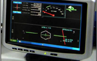
The GPS navigation module is an integral part of the IMPAC data acquisition system, and is designed to utilize the outputs of a GPS navigation system for special navigation tasks, such as waypoint navigation and 2-and 3-dimensional survey grid navigation. The unit’s PGU display is usually mounted on the aircraft or helicopter's instrument panel in the cockpit, displaying steering instructions, track guidance and other essential information to the flight crew. The PGU is a colour graphic display that provides information to the pilot / navigator that includes:
- Map, survey polygon and flight lines
- Current Location
- Ground Speed
- Altitude
- Line number
- Crosstrack
- Distance to Go to the Survey Boundary
- Line Heading
3D-NAV Drape Flying
To obtain high resolution geophysical data, survey aircraft need to be flown at a consistent height above the ground, maintaining a consistent and safe altitude (the drape surface) on the two orthogonal survey line directions. McPHAR operates a computer-assisted system, 3DNAV, to enable our flight crews to maintain an optimal flight altitude (drape surface) during surveying while at the same time ensuring that primary and control lines intersect at the same altitude. The result is a vast improvement in the quality of the high resolution data acquired, particularly in hilly or mountainous terrain.
The critical elements in the design of the drape surface are the safety of the data acquisition operation, the (median) performance parameters of the survey aircraft for climb/descent rates and the desire to drape as closely as possible to the specified survey altitude. To create a drape surface, a digital terrain model of the survey area is modified using proprietary McPHAR software to reduce all slopes to within the capabilities of the survey aircraft to safely climb and descend. The preplot survey design is stored as the on-board navigation information for the pilot to fly with, using a precision radar altimeter and real-time differentially corrected GPS height for vertical and horizontal control.
Some of the benefits of drape flying are:
- Clients can review the drape surface prior to the survey commencing and can see what altitude the sensors will be at any point in survey area
- Control and traverse lines intersect at more or less the same altitude, greatly facilitating the leveling of the acquired data
- A preplanned drape survey enables the flight crew to fly a better, safer survey. McPHAR’s 3D-NAV system, to a large degree, removes the guess work out of maintaining a safe and consistent survey altitude
-
Optimization of the survey line direction results in a more efficient use of exploration dollars
 |
 |
|
| GPS base station in the field. | The PGU display. |